On March 18, 2026, NASA Earthdata published a feature on its new Low-Cost Air Quality Sensor Harmonization Database, a collection built from ground-based sensor packages that cost less than $1,000. The dataset is designed to make inexpensive air-quality measurements easier to find, compare, and use alongside satellite and modeling data.
The article centers on Kristen Okorn of NASA’s Ames Research Center, who leads development of the database. Her team began from INSTEP, a low-cost sensor network she deployed in California, then expanded the idea into a broader archive that now includes contributions from more than 20 networks across 80 countries.
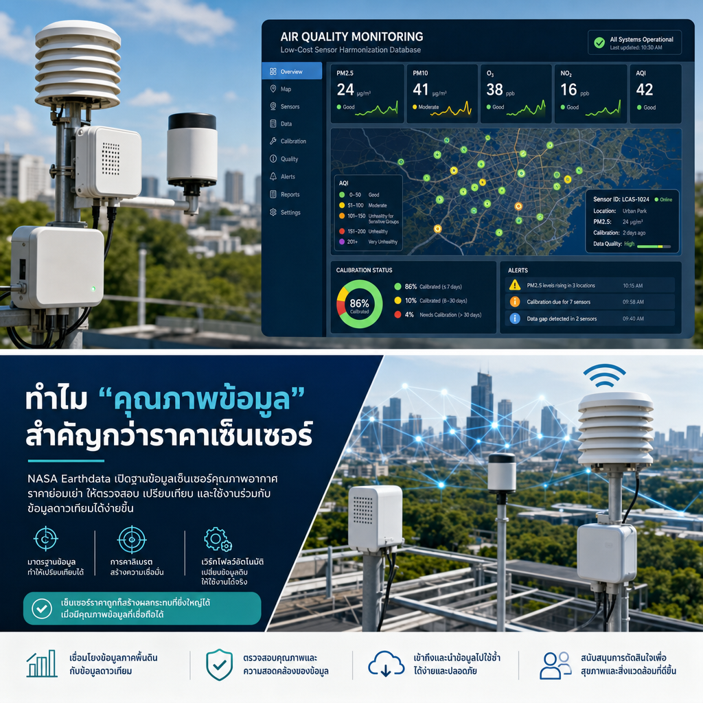
The engineering problem is straightforward but important: low-cost sensors are widely deployed, but the data are fragmented, formatted differently, and often difficult to trust without calibration and quality context. That makes the information less useful for researchers, public agencies, and community operators who need fast, comparable signals rather than raw device outputs.
The result is a practical example of how data infrastructure changes the value of hardware. When sensor data are standardized, quality-flagged, and made searchable, inexpensive devices can support satellite validation, local pollution studies, and better operational decisions.
Why low-cost sensors matter
NASA’s article makes a clear case that air quality monitoring is no longer limited to a few high-end instruments. Low-cost devices can measure carbon monoxide, nitrogen dioxide, particulate matter, and related pollutants, which makes them useful for research teams, city governments, and citizen scientists.
That reach matters because air quality is not uniform across a city or region. Ground-level measurements can reveal local variation that satellites may miss, especially in areas where regulatory monitors are sparse. For organizations building environmental programs, the lesson is that affordable sensors can expand coverage, but only if the data pipeline is strong enough to preserve meaning.
How NASA made the data usable
NASA’s team focused on harmonization, not just collection. The database reformats observations from different networks into a common structure, using the ICARTT standard that many NASA atmospheric datasets already follow. That choice reduces friction for users who need consistent inputs across multiple sources.
The archive also includes metadata, calibration notes, and quality levels so users can judge whether a dataset fits a specific application. NASA says the team is working to make discovery easier through Earthdata Search and an ArcGIS map, with data extending back to 2012.
This is the part that matters most to operations teams: the database is not only a storage layer. It is a workflow layer that turns scattered sensor feeds into something searchable, comparable, and auditable. That is what makes the data actionable for validation, analysis, and broader reuse.
What this means for connected operations
For Paw Partners’ audience, the relevant takeaway is that sensor value depends on the surrounding software system. A connected device is only as useful as its calibration workflow, metadata model, alerting logic, and dashboard experience.
In practice, that means designing the full path from field device to decision maker: device onboarding, automated ingestion, validation rules, exception handling, and a dashboard that shows where the data can be trusted. The NASA example shows why those layers are not optional when the sensor fleet spans multiple networks or deployment contexts.
The same approach applies in industrial, environmental, and smart-building programs. Whether the goal is air quality, energy efficiency, or asset reliability, the business outcome comes from turning raw measurements into consistent operational visibility.
Reference and next steps
NASA also notes that the database team plans to add visualization tools, Jupyter notebooks, data processing automation, and more international networks. That roadmap points toward a mature platform mindset: lower the contribution burden, standardize the data, and make the results easier to consume.
For organizations building connected monitoring systems, that is the pattern to copy. Start with reliable devices, then invest in integration, quality control, and user-facing tools that help teams act faster and with more confidence.
Source: High Value Air Quality Data From Inexpensive Sensors on NASA Earthdata, published March 18, 2026.